Little Long Lac Gold Area (Part 2 of 4)

View of the Elmos mine in 1938, looking north and east. The headframe is in the cluster of structures to the east. A trestle for ore cars runs from the north shore to the south shore. Harry Fisher collection.

A Brief Geological Resume of the Little Long Lac Gold Area
Prepared for “Gold” by Percy C.
[sic] Hopkins, Consulting Geologist


Part 2 of 4 from Gold magazine in August 1934


Tony Okland
(sic) ̶ The Trapper Whose Dreams Came True

How would you like to wake up some morning and find yourself rich after
years of struggle that seemed to lead nowhere? Few people are fortunate
enough to experience this super-thrill but if you want to know what its like
ask Tony Okland, with Tom Johnston, the original staker of Little Long Lac
Gold Mines.

For over twenty-five years Tony wandered up and down the North Country
hunting and trapping, and keeping a weather eye open for pay streaks. Trapping
in winter and working on the section in summer Tony managed to keep body
and soul together after a fashion. Less than two years ago Fortune favored
him with a smile, and to-day he is comfortably well off.

In June, 1932, Tony accompanied Tom A. Johnston on an exploration and
prospecting trip on Little Long Lac. While on their way to several locations
which Tony had previously investigated in a casual way they came across a
likely looking outcrop of quartz a foot and a half under water. The vein so
whetted their interests that they staked claim T.B.10560, which was the nucleus
of one of the most spectacular gold discoveries to date, the Little Long Lac
Gold Mines, Limited.

It is reported that Tony received for his share, $25,000 in cash and 100,000
shares of Little Long Lac. With this stock quoted on the Standard exchange
at a current price in the neighbourhood of $7.70 a share you can figure out
whether Tony is in luck or not. Tom Johnston received an equal interest.
“Sure, I got some two, tree hundred t’housands, I guess,” Tony will admit
with a grin, if you ask him about it. Still in the prime of middle life Okland
is looking forward to years of freedom from financial worries. Almost any day
you can see him skimming over the Lac waters in a fine high-powered
mahogany cruiser, or playing the congenial host to his friends. Tony believes
in keeping money in circulation.


Tom Johnson ̶ Discoverer of Five Principal Gold Finds

If a prospector makes one good find in his lifetime he can consider himself
fortunate, but to make five principal gold discoveries speaks volumes for the
judgment of the finder. Such has been the experience of Tom A. Johnson who
successfully located what are now the Bankfield, Long Lac Lagoon, Little
Long Lac, Johnson-Nipigon and Dik-Dik properties.

Twelve years ago Johnson and his brother prospected much of the country
in the Long Lac District and staked claims, although they found nothing
that could be termed spectacular. Among those claims staked in 1922, two of
them later became part of the Johnson-Nipigon Mine(1).

In the latter part of 1931 Johnson asked Robert Wells, of Tashota fame,
to accompany him into the Little Long Lac section. After a day of prospecting
without results Bob and Tom felt anything but cheerful when October 3
dawned in a dismal rain. The story continues in Johnson’s own words.
“Rather than waste the day at our camp I suggested that we cruise around
the shore-line. Twenty minutes from our camp I noticed an outcrop in the
lake and headed the canoe towards the ledge. Stepping out I broke off a piece
of rock which was well mineralized, and with some difficulty I broke off a
piece of quartz about two and a half feet under water with a nice showing of
free gold on one side.”

Eighteen claims were staked and samples tested which eventually resulted
in Percy Hopkins optioning the property, and drilling was carried on by the
Sudbury Diamond Drilling Company. This was the beginning of the Bankfield
mine.

In June of the same year Johnson and Tony Okland made a trip on Little
Long Lac. Listen to Johnson tell this yarn of the beginnings of the now famous
Little Long Lac Gold Mines.
“Okland told me of a showing he had seen some years before a short
distance around the point. About seventy feet north of this showing we spotted
some quartz fragments in about a foot and a half of water close to the shoreline.
The finding of a little free gold whetted our appetite. We dug up several
pounds of the quartz fragments on the lake shore and I staked claim T.B.10560
the same day. We continued our staking until we had fifteen claims.”

Johnson sent samples out to Percy Hopkins who interested Joseph Errington
in the showing. Negotiations eventually resulted in the formation of the
Little Long Lac Gold Mines, Limited.

Aerial view of the Elmos mine in 1938. On the far right, smoke rises from the new community of Geraldton. Harry Fisher collection.

And still Tom continued to look for some more indications of the king of
metals. Let him continue his own story.
“About ten days after making the Little Long Lac find Okland and I went
to the point on the west arm of the lake where the portage from the Mosher
comes out. Finding plenty of evidences of gold I organized a party and we
staked 18 claims. Then we consolidated the claims in a group, with our
eighteen claims, Paddy Barry’s claim, Archie Gillies’ claim and Charlie Ellis’
three claims making up the property. This was optioned to the Lake Maron
company who, after doing some work and staking other claims, formed the
Long Lac Lagoon Mines(2).”

Section of Map No. 44d, annotated, Little Long Lac Gold Area, 1935. Ontario Department of Mines.

Tom Johnson’s spectacular streak of discoveries was not over yet. On June
8, 1933, Johnson, with Art Koch, went to the north end of Dillabough Lake.
Here the two separated, Johnson going in a southeasterly direction until he
came to the north shore of the Atigogama Lake.

“I cruised west along the shore for about an eighth of a mile,” states Tom,
“and then struck northward over the hill. Near the top I came across a small
rather well-mineralized outcrop.”

Further scouting revealed two other outcrops. Johnson took some samples
which he later panned and got some nice tailings. Returning the next day Koch
and Johnson staked eighteen claims. Johnson optioned his claims to K. W.
Fritzsche, engineer for the Dik-Dik Exploration Company(3).

Commenting on these outstanding finds Johnson said, “The fact that all
these discoveries have lately proven to possess almost spectacular possibilities
as mines, gives me, of course, considerable satisfaction as it would any prospector.
But, what seems most interesting to me, is that it proves the old adage
about truth being sometimes stranger than even the most daring fiction.”


(Continued in Part 3)

Partly built headframe of the Elmos mine ca 1938. It is surrounded by rock excavated from the shaft. Collection of Charles Dobie/E.O. Berger.

ENDNOTES

1  Johnson-Nipigon Mines Ltd. was not a mine, it was a prospect. Staked by Thomas Alexander Johnson in 1923, it was worked by the prospector on and off still 1933. Johnson did extensive stripping and drilled 9 holes, the record of which has been lost. Its importance lies in its location, being 0.8 km west of the shaft of the Tashota-Nipigon mine. This mine poured its first brick in 1935 and over the next few years had a limited production. The shaft is located on the South Onaman River and accessed today by the Kinghorn Road (a bush road) off Hwy. 11, east of Jellicoe. It is the most northerly producer in the Tashota-Kowkash-Greenstone gold area.

2  Longlac Lagoon Mines Ltd. was a creature of Oro Plata Mining Co. Again, Longlac Lagoon was a prospect, not a mine.

Mosher Lake is just a few hundred yards south of “the west arm of the lake”, meaning Barton Bay of Kenogamisis Lake. This gold find was less than a mile west of the Little Long Lac discovery.

Longlac Lagoon (a subsidiary of Ora Plata) performed trenching, miscellaneous surface work, and 21,500 feet of drilling.

In 1935, Longlac Lagoon held a block of 52 claims, which were all transferred to T.A. Johnson. In 1936, Johnson incorporated Elmos Gold Mines Ltd., and in 1938, shaft-sinking began.

The Elmos mine (a composite name of Ellis and Mosher) is often described as situated on an island. In reality, it is situated on the marshy shoreline of the west arm of Barton Bay. A trestle ran from the north shore to the south shore to carry ore cars. The ore was transported by truck to the Northern Empire mine in Beardmore for processing.

The mine ran, with interruptions, until 1948 under the name Talmora Longlac. As a gold producer, it was a huge disappointment. It produced 1,415 ounces, along with a few ounces of silver, for a total value of approximately $53,168.

It goes without saying that more gold was poured into the mine than was ever extracted from it.

Tom Johnson never lived to experience the disappointment. He died in 1944.

Sidebar – Tombill Gold Mines Ltd. was incorporated in 1935. The name is a composite of the names of brothers Tom and Bill Johnson. The property adjoined the Bankfield mine to the west. The Tombill was the sixth producer in the Geraldton (Little Long Lac) gold camp, producing 68,739 oz.

In 1959, Tombill Gold Mines Ltd. changed its name to Tombill Mines Ltd. (established in 1935). This company now controls property west of Mosher Lake which used to be controlled, first by Longlac Lagoon, then by the Elmos/Talmora Longlac mine.

The exciting news is that Tombill Mines Ltd. started a drilling campaign in January 2021. To the east of Mosher Lake is property now controlled by Equinox Gold Corp.  (formerly Premier Gold, then Greenstone Gold). The Equinox Gold property continues to run westward, so that it is now interrupted by the swath of claims on which Tombill Mines is exploring. To date, drill results have not been reported. Meanwhile, Equinox is starting construction of an open pit just east of Mosher Lake.

Tom Johnson would be proud to know that his name, and his family name, is living on in the Little Long Lac gold field.

3  The Dik-Dik property was staked by T.A. Johnson in 1933 and acquired by Dik-Dik Exploration Co. In the first year, the company at mined ore from an open cut and then sank a shaft to 160 feet. In 1935, the company installed a 20-ton per day mill, after which the property became Orphan Gold Mining Corp. In 1936, the mine became Sarmac Gold Mining Operations Ltd., but work was suspended indefinitely after having produced 2,460 ounces of gold and 1,558 of silver. The property is located on a ridge just north of Atigogama Lake on the Kinghorn Road.

PHOTOS

03j View of the Elmos mine in 1938, looking north and east. The headframe is in the cluster of structures to the east. A trestle for ore cars runs from the north shore to the south shore. Harry Fisher collection.

03k “PROSPECTORS WHO WON FORTUNES . . . “ Gold article.

03l Aerial view of the Elmos mine in 1938. On the far right, smoke rises from the new community of Geraldton. Harry Fisher collection.

03m Section of Map No. 44d, annotated, Little Long Lac Gold Area, 1935. Ontario Department of Mines.

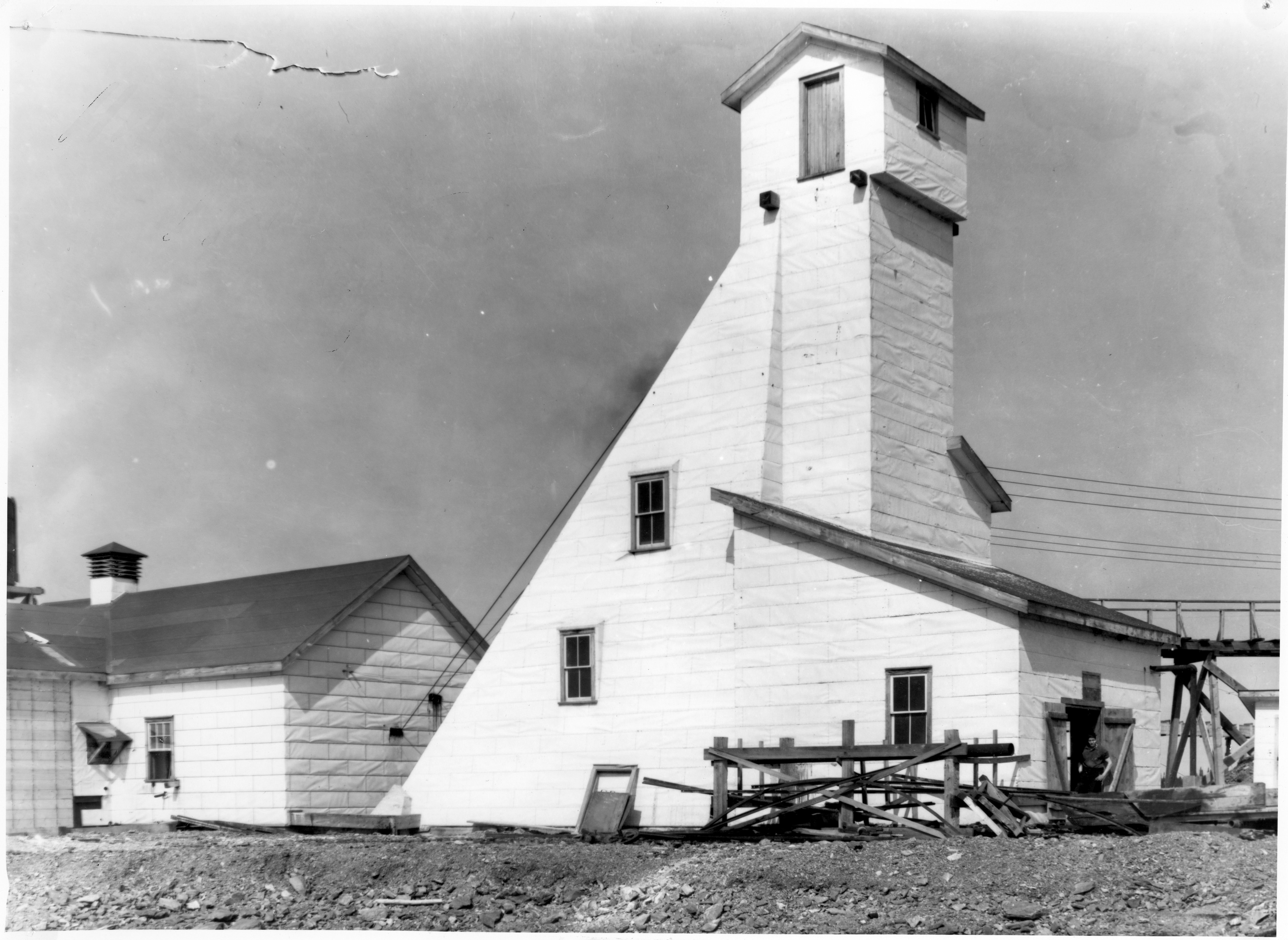
03n Partly built headframe of the Elmos mine ca 1938. It is surrounded by rock excavated from the shaft. Collection of Charles Dobie/E.O. Berger.

03o Long Lac Lagoon ad.

03p Oro Plata ad.

Posted in WRITING | Leave a comment

Little Long Lac Gold Area (Part 1 of 4)

Building the first headframe for the Little Long Lac mine ca 1933. Private collection of Ross Houghton/Ron Duhaime.

A Brief Geological Resume of the Little Long Lac Gold Area

Prepared for “Gold” by Percy C.[sic] Hopkins, Consulting Geologist1

Part 1 of 4

GEOLOGY; a large area of rocks favourable for gold prospecting extends from Lake Nipigon to Long Lac, a distance of 75 miles. The Canadian National Railway passes through the gold belt which is upwards of 25 miles wide in places. Gold is being produced at the Beardmore mine and a 200 ton mill is being constructed on the Little Long Lac Mine and diamond drills are finding ore intersections on several properties. Shaft sinking is under way on the McLeod Cockshutt and Dik Dik. Many new gold discoveries have been made in the area already during 1934.

The geology has been mapped in a general way and reported on by T. L. Tanton and the late Dr. A. G. Burrows, both of whom reported favourably on the possibilities of finding gold deposits in the area. G. Langford mapped the eastern part of the field in more detail. Dr. E. L. Bruce is mapping the area in detail at present.

The rocks consists largely of Keewatin lavas, tuffs, iron formation and rusty carbonate with much intermingled fragmental rock, some of which are Timiskaming in age. They have been closely folded into synclines and anticlines whose axes strike nearly east and west with the beds dipping from 75 degrees to vertical.

A few porphyry dikes are present while Algoman granite masses occur in places. Lamprophyre, diabase, diorite and gabbro intrusives are common in some properties.

The gold deposits are of various types. The Little Long Lac vein consists of parallel quartz veinlets in a shear zone in greywacke schist and tuff. Gold is frequently visible in the quartz and associated with small quantities of pyrite, arsenopyrite and stibnite.

Quartz veinlets carrying similar minerals in diorite and diorite tuff occur on the Long Lac Lagoon near the Mosher boundary. Gold also occurs in a quartz stringer in porphyry on the Lagoon.

On the Dwyer and Dalton and in one of the McLeod-Cockshutt veins the gold values occur in part in quartz veins cutting iron formation. Much zincblende and galena are present in the Dik Dik vein which occurs near the contact of granite and Keewatin.

The Bankfield veins contain mispickel, chalcopyrite, pyrrhotite, pyrite and gold and occurs in silicified greywacke intruded by porphyry.

The veins on the Hard Rock are partly in arkose.

+ + + + +

Mr. Hopkins who furnished the above information was instrumental in interesting capital originally in Beardmore, Little Long Lac, Bankfield and other properties in the area and is financially interested in some of these properties. He has been one of the most active factors in bringing the various favorable areas to the attention of mining interests. He regards Tom Johnston as the key prospector of the district, the latter having made the discoveries on Bankfield, Little Long Lac (with Tony Okland[sic]) Long Lac Lagoon and Dik Dik.

(Continued in Part 2)

ENDNOTES

Percy Eugene Hopkins, U of T graduate in 1910. Ancestry.ca.

1 Percy Eugene Hopkins was born in Southern Ontario in 1887 and obtained a degree in mining engineering from the University of Toronto. From 1914 to 1924, he worked for the Geological Survey of the Ontario Bureau of Mines. In this capacity he explored, described, and mapped many areas in Ontario’s North. In 1923, the United States Geological Survey published a volume with included a bibliography of his numerous  contributions up to 1918 (Geologic Literature on North America, 1785 – 1918, Bulletin 746, by John M. Nickles, United States Geological Survey, p. 525.) He wrote 10 articles and co-wrote 7 articles in that time period. Up to 1934 (the date of publication of this Gold edition), he met and knew many players in the Greenstone/Kowkash gold areas, including Tom Johnson. Percy E. Hopkins numbers among the many unsung great mining personages who have yet to be recognized in the Canadian Mining Hall of Fame. Hopkins retired in 1954 and spent his days, according to his obituary, “golfing, curling and watching the stock market”. He passed away in 1976.

Bibliography from Bulletin 746.

PHOTOS

03a  Building the first headframe for the Little Long Lac mine ca 1933. Private collection of Ross Houghton/Ron Duhaime.

03b  Title of Gold magazine.

03c  “Pit in high grade ore on Little Long Lac Gold mine . . . “

03d  “Mrs. Percy Hopkins and daughter . . . “

03e  “The original discovery on the Little Long Lac Gold mine . . . “

03f  Percy Eugene Hopkins, U of T graduate in 1910. Ancestry.ca.

03g  Bibliography from Bulletin 746.

03h  Ad in Gold magazine.

Posted in WRITING | Leave a comment

Little Long Lac-A Sleeping Bonanza (Part 2 of 3)

Aerial view of Little Long Lac mine under construction in the fall of 1934. Note the hydro power line spanning Barton Bay. The mine received power on September 6, 1934, the cheapest mine power in Canada in exchange for constructing the line from Beardmore. Just to the right and down from the water tank is the headframe. To the right out of frame is Rosedale Point. Greenstone History collection.

One of Ontario’s most remarkable deposits found in an area long neglected, and with few signs on surface  ̶  spectacular in ore developments and in rise of shares from 25 cents to $7.70

Written for “Gold” in the Field by Ted Elliott

Leaving their Marks

About a mile and a half from [Hardrock] station on the eastern shoreline John Rae, president of Roche Long Lac, has built a fine bungalow. A little farther on Bert Tyson’s place makes a land mark in the wooded skyline, and just around a bend in the shore, Tony Okland has built an attractive establishment on a point of land reaching out into the lake. Another mile and you can see the stilted tripods of drills where “Hardrock” Bill Smith has been probing beneath the surface of the water.

On the western side of the lake there are no permanent buildings as yet but that does not mean that the country lacks inhabitants. The smoke from camp fires pillar and sway with every passing breeze. Prospectors, Indians, surveyors all wave a cheery greeting as you pass.

Opposite the drills of the Hardrock outfit you swing sharply westward through a narrow stretch of water into a larger expanse of the lake6. About a mile straight ahead from behind a green-clad jut of land the forest is topped by the black stacks of the Little Long Lac power-house pointing into the blue like two gaunt fingers. Half a mile to the left a low dock running out into the water marks the beginning of the trail that leads into the Macleod-Cockshutt property7. In a few minutes the canoe splutters around the point and the Little Long Lac camp, set in a beautiful woodland scene, breaks into view.

Not far from the landing stage is the original vein which prompted Tony Okland and Tom Johnson to stake the first claim, T.B. 10560, which was the beginning of this now famous enterprise. The vein itself is not very impressive. A brownish red, irregularly shaped strip of rock runs exposed along the surface of the country rock for a distance of approximately five hundred feet. It varied in width from a foot to four feet.

Claims are Restaked

Tony Okland first staked around Little Long Lac in 1931 but lack of funds prevented him from carrying on the necessary assessment work, and the location reverted to the Crown8. Later other finds of gold ore were being made in the district. Together with T. A. (“Tom” Johnson, Okland looked over the situation once more and restaked fifteen claims after making the discovery of a high grade deposit in a vein showing on the shore of the lake.

These samples were shown to Alan Barton, mining engineer, at Port Arthur, who liked the look of the vein material so well that he immediately wired Mr. Errington with whom he had a close association. The latter wired back telling Mr. Barton to look over the property. Two days later Mr. Barton again sent a wire telling Mr. Errington he had better come up himself as “this one looks important.”

When Joseph, himself, made the trip and examined the find, a deal was made right on the spot. The “office furniture” was a log in front of the prospectors’ tent. Tom Johnson, Tony Okland, Barton and Errington were present and drew up the agreement on such “stationery” as Mr. Errington, could produce from his inside pocket.

Image from the August 1934 edition of Gold magazine. Note the twin sheave wheels atop the headframe. A cable passes over the grooved sheave wheel or pulley to raise or lower the cage in the mine shaft.

From 25 Cents to $7.70

As an incorporated entity Little Long Lac Gold Mines Limited came into being on January 26, 1933, with an authorized capital of 2,000,000 shares of no par value, 1,800,000 shares of which have been issued at date of writing (July 17th). Holdings now comprise 35 claims or approximately 1,200 acres in several groups, with the main vein system having a strike of at least two miles on the central property and well protected as to dip. The officers are Joseph Errington, president and general manager; Thayer Lindsley, vice-president; L. A. Macdonald, secretary-treasurer; and directors are Mr. Errington, Mr. Lindsley, A. B. Gordon, Toronto; W. S. Morelock, Toronto, and D. M. Morin of Sudbury. Alan Barton, M.E., has been mine superintendent since operations commenced.

The parties to the agreement were Okland and Johnson as owners and Errington as purchaser for the Sudbury Diamond Drilling Company of which Errington is a leading shareholder. Later in a lawyer’s office the mining man’s document was translated into the stilted measures of legal terminology. This was on August 8, 1932, or approximately two years ago, since when a number of things have happened.

A relatively small sum of money  ̶  considering the millions at which Little Long Lac shares now are valued  ̶  was agreed upon, and a diamond drilling campaign was commenced. The cores, when drawn, split, assayed, and correlated showed a continuous ore shoot for a distance of 600 feet in length and 400 feet in depth. Five hundred feet of this shoot showed $30.00 ore. Was it a beautiful mining picture? Probably no other young prospect in Central Canada ever had shown such a consistent set of drill cores, as an indication of a major body of high grade ore. Nor have many proved as consistently the same conditions in actual mining operations.

Early in 1933 the company offered 300,000 shares of its capital stock to the public at 25 cents per share, which was subscribed readily. This compares with a high for the shares of $7.70 recorded on July 17, and giving the property a market valuation of $13,860,000, which, while a remarkable position for a proven prospect approaching the milling stage, also indicates the belief of the public and the mining fraternity in the deep-seated character of pre-Cambrian ore bodies when developed by mining men of experience. In addition to this, it is obvious that large blocks of the stock are closely held.

[Continued in Part 3]

ENDNOTES

6 At this point Barton Bay stretches westward from the narrows now spanned by the locally named First Bridge.

7 The trail to the Macleod -Cockshutt property eventually became Mine Road after the causeway and bridge spanned Barton Bay. Mine Road later became Highway 584.

8 Tony Oklend had claims staked on his gold showing at the Main Narrows of Kenogamisis Lake. The locally named Second Bridge, a renowned fishing spot, spans the Main Narrows. Almost directly north of the narrows is the site of Hardrock Station.

The headframe and boiler house in early 1934 with snow still on the ground. Geraldton Public Library.

PHOTOS

2d Aerial view of Little Long Lac mine under construction in the fall of 1934. Note the hydro power line spanning Barton Bay. The mine received power on September 6, 1934, the cheapest mine power in Canada in exchange for constructing the line from Beardmore. Just to the right and down from the water tank is the headframe. To the right out of frame is Rosedale Point. Greenstone History collection.

2e Image from the August 1934 edition of Gold magazine. Note the twin sheave wheels atop the headframe. A cable passes over the grooved sheave wheel or pulley to raise or lower the cage in the mine shaft.

2f The headframe and boiler house in early 1934 with snow still on the ground. Geraldton Public Library.

Posted in WRITING | Leave a comment

Little Long Lac-A Sleeping Bonanza (Part 1 of 3)

Portrait of Joseph Errington in the tribute from the Canadian Mining Hall of Fame.

JOE ERRINGTON  ̶  NO FOOLIN’

“Joe” Errington, son of Simcoe County, drawn as a youth by the call of mining to Sudbury, where he pioneered with the Orford Copper Co. (feeble infant of great portent out of which grew International Nickel) then to Northwest Territories to discover first high grade coal north of the Athabaska, later to explore mining areas of Mexico and the Western States, and then back to his own country to enter his real career as the distinctive Canadian type with force, energy and command of capital, who gets behind the prospector. He is of the 32nd degree of mining men1 who get most of the Canadian deposits, which doesn’t mean things have come easy. Sat steady in the boat when the 1928 boom in Sudbury Basin was led by his Errington mine, controlled by Treadwell Yukon, which today is closed down through zinc and lead slumps and ore complications. He is the kind of developer whose operations are followed by booms in which he does not believe, but does not regard as his function to control, even if he could.

Has a real charm of manner, and a voice of low, mellow pitch, but  ̶  no foolin’. It’s not good to get in his way when he’s into the business of breaking open a mine. If he appears aloof and hard, it doesn’t match the stories of his loyalty for old associates, big and little, matched by hard opposition for those he bumps or who bump him. One can believe that the game means more to him than the winning of the game.

Usually doesn’t get enthusiastic, but he sure feels that Little Long Lac is the thing he has looked for all his life, and intends to give it all he has, believing it will be worth its price and will vindicate its present market rating in dividend returns. His life has been and will continue to be, the open vistas of the North and the opened rocks of a real discovery  ̶  and the great quest for a mine among mines. Has had over sixty years of hard going, but looks as fit as an Olympian athlete, and with a mine like Little Long Lac behind him is expected to go on in his chosen field as doggedly as ever for a long spell of years, and  ̶   no foolin’!1

W. J. L.

One of Ontario’s most remarkable deposits found in an area long neglected, and with few signs on surface  ̶  spectacular in ore developments and in rise of shares from 25 cents to $7.70

Written for “Gold” in the Field by Ted Elliott

One of the most substantial, spectacular and rapid developments in the history of Northern Ontario mining is taking place on the eastern shore of the Little Long Lac, Port Arthur Mining Division, by the company of the same name, Little Long Lac Gold Mines Limited, President, Joseph Errington, veteran Canadian mining developer.

This remarkable property, designated as an important coming producer even by the most conservative, has been the spearhead of one of the most intensive rushes ever undertaken by Ontario prospectors. Though “many have staked and few may be chosen”, the fact remains that a great many operators are working on well-mineralized veins, with gold showings, and diamond drilling, trenching and shaft sinking bid fair to establish more than a single mine in the area. The work now under way is a remarkable commentary on the number of gold mines that may be “slumbering” under clay, muskeg or lake bottom[,] for the Long Lac area showed nothing outstanding to geologists or mining men to indicate its hidden riches. A great flat area with few outcrops, it remained for roving prospectors like Tony Okland[sic] and Tom Johnston[sic] to find “the golden key” to great wealth while persisting to search for gold on claims staked years before and given up for lack of mining interest.

View looking NNE from the mine to Rosedale Point ca 1934. The annotation in pen is wrong, for there is no Mine Road running left to right, which was constructed in 1935. The structure with the cross painted on the roof is the Little Long Lac Hospital, the only building in Rosedale Point not standing today. Geraldton Public Library.

Although the Little Long Lac company has only been incorporated under Ontario charter since January 26, 1933, development has gone forward with such rapidity that to-day a 200-ton mill is under construction. A three-compartment shaft is down 700 feet and workings have been extended for over 800 feet at some levels. Offices, power plant, assay house, and bunkhouse and cookery to accommodate 150 men have been built and are occupied, as well as half a dozen bungalows and a club house for the officials3. In addition to completing this ambitious project, the erection of a power transmission line is being pushed with all possible speed from the Northern Empire Mines, 48 miles to the west.4 Joseph Errington and his mine manager, Alan A. Barton, M.E., are to be congratulated on their creditable accomplishments within such a comparatively brief time.

“Bucked Up” the District

The energetic action of this company is noticeable not only on the location itself but is reflected in the heightened morale and the spirit of the people throughout the whole countryside. Immediately upon the news of the discovery by Tony Okland and Tom Johnson, the original stakers, prospectors poured into the district by the score. To-day over three dozen organizations are actively engaged in exploring the veins and shear zones on their claims, and a surprisingly large number can lay claim to respectable showings of commercial rock on surface, or good indications in drill cores.

What this godsend of activity has meant in a business way to the purveyors of supplies can best be appreciated by those who experienced the lean years that followed Terrible ’29. At every little station from Long Lac to Jellicoe merchandise is piled high along the tracks or waits in strings of box cars on the sidings to be transported down the lakes in boats. Modern editions of the old York boats equipped with marine gas engines pass to and fro, sometimes towing a heavily ladened barge. Launches and canoes fitted with outboard motors piled high with bundles and boxes risk submersion as they chug along from landing stage to some obscure trail at the water’s edge farther down the lake. Everyone is busy and, what is more important, wears the happiest of smiles. They’re making money in the Long Lac country this summer.

From Hardrock Station (now re-,christened Little Long Lac5) to the Little Long Lac mine by boat is more like a trip through a summer resort region. The harsh, rock-ribbed landscape usually associated with lode mining is entirely absent. To skim over the scintillating waters on a flawless July morning in the front of a kicker canoe is an exhilarating experience. On every headland and windswept point freshly cut stakes gleam sharply in the sunlight against the verdant green of the bush. White tents or cabins of freshly-peeled logs interrupt the marching ranks of pine and birch at intervals along the water’s edge.

[Continued in Part 2]

ENDNOTES

1 This rather grandiose title comes from Freemasonry. Freemasonry is made up of three degrees. When someone joins, he goes through the process of receiving the degrees and becomes a third degree Master Mason. At this point, he is a full Member of the Fraternity and a peer to all other Masons throughout the world. The term “32nd degree Master Mason” is often used in a colloquial  sense for a third degree Master Mason.

2 Joseph Errington was inducted into the Canadian Mining Hall of Fame in 1993. He passed away in February 1942 at age 70 after a very eventful life.

3 The bungalows and club house are still standing and occupied as residences in the housing subdivision that adjoins the decommissioned mine itself to the east. The community is locally called Rosedale Point. Another subdivision a couple of hundred metres further west is locally called Little Long Lac Townsite.

4 The hydro power line followed the CNR railway to a point just west of Geraldton station, where it angled southward to span Barton Bay of Kenogamisis Lake (aka Little Long Lac).

5 Hardrock Station is located 3 miles east of Geraldton Station on the north shore of Kenogamisis Lake. It is named after “Hard Rock” Bill Smith, discoverer of the property that would become Hard Rock Gold Mines, Ltd. Hardrock Station always retained its original name in spite of what this article suggests.

A photo montage from the Maclean’s magazine article published on February 1, 1935, titled Little Long Lac.

PHOTOS

02a Portrait of Joseph Errington in the tribute from the Canadian Mining Hall of Fame.

02b View looking NNE from the mine to Rosedale Point ca 1934. The annotation in pen is wrong, for there is no Mine Road running left to right, which was constructed in 1935. The structure with the cross painted on the roof is the Little Long Lac Hospital, the only building in Rosedale Point not standing today.

02c A photo montage from the Maclean’s magazine article published on February 1, 1935, titled Little Long Lac.

Posted in WRITING | Leave a comment

08 May 1922 for CNR, Ontario

Virgin Falls in 1918. At this point the Nipigon River starts on its journey from Lake Nipigon to Lake Superior.
Nipigon Museum The Blog.

08 Article in Canadian National Railways Magazine

FISHING – Where to go

by S.H. Howard

(an extract)

Almost every day now, several times a day perhaps, some one will lean over the ticket counter and ask [our] agent of the Canadian National Railways System “Say, where is a good place to go fishing? Where can I go to get a mess of speckled trout?”

He will put the question in an eager, confiding manner, taking it for granted that the agent will know . . .

And many of the Canadian National Railways agents are equipped to give authoritative

answers to the questions of the anxious passenger . . .

The glamor of this great new sporting Empire of the North seems to cling to the ticket rack and the timetables of the transcontinental trains. The Agent who likes to answer the fisherman’s questions with helpful information, visualizes the country as he studies the map, and is always curious and alert for information concerning the places represented by the black dots with the fascinating names scattered along the lines. And gradually he accumulates a store of information from railway men, travelers, natives, railroad literature, newspapers, magazines  ̶  from here, there and all over.

He writes the name of a station in the North Country on a ticket strip  ̶  some place where but a few years ago The Hudson’s Bay Company’s post was the only evidence ‘of civilization within hundreds of miles, He sells the tickets to a man who has perhaps only a week or a fortnight to get in and get out of a region which not so long ago might have required the best part of a summer and the aid of a crew of expert canoemen to penetrate. He pictures this man of to-day, going aboard his parlor car, traveling in civilized comfort into the very heart of the newly opened wilderness, dining a la carte, reading, smoking, chatting, sleeping in luxury compared to the conditions which prevailed in this region but a decade ago  ̶  and alighting after a day and a night  ̶   perhaps more, perhaps less  ̶   in the very heart of the best fishing and hunting grounds of the continent . . .

Of course, everybody has heard of the world-famous Nipigon, and its world-record splendid trout. Nipigon Lodge, the C.N.R. hotel for sportsmen, is convenient to Virgin Falls, probably the best fishing water of the river. Innumerable trout streams entering Lake Nipigon above have yet to be fished save the casual Indian trapper who throws a piece of gill net across a narrow channel once in a while, maybe, to get a few fish for his family and his dogs.

Record brook trout caught in the Nipigon River in 1936: 25 inches, 6 lb., 11 oz. Edwin Mills/Nipigon Museum.

Give the fisherman who asks for advice as to where to go to catch trout a few folders and timetabIes and a little ginger talk about this Northern Ontario oountry, and he’ll pick out the spot to get off at himself. He can hardly go wrong if he goes up there . . .

Menu for the farewell dinner of Virgin Falls Hydro employees, on August 28, 1926, on the occasion of the completion of the control dam.
Duncan Cocktails
Virgin Celery and Olives
Leoroyds in the Soup
Damned Trout
Roast McKirdy’s Chicken
MacDougall Sauce
Beans a la Mitchell
Speckled Spuds
Dixon’s Salad
I’ll Scream — with Wayfarers
Cheese It Now
Coffee and Mumm
God Save the Poor Fish

John McKirdy/Nipigon Museum
.

PHOTOS

1 Virgin Falls in 1918. At this point the Nipigon River starts on its journey from Lake Nipigon to Lake Superior. Nipigon Museum The Blog.

2 Record brook trout caught in the Nipigon River in 1936: 25 inches, 6 lb., 11 oz. Edwin Mills/Nipigon Museum.

3 Menu for the farewell dinner of Virgin Falls Hydro employees, on August 28, 1926, on the occasion of the completion of the control dam.

Duncan Cocktails

Virgin Celery and Olives

Leoroyds in the Soup

Damned Trout

Roast McKirdy’s Chicken

MacDougall Sauce

Beans a la Mitchell

Speckled Spuds

Dixon’s Salad

I’ll Scream — with Wayfarers

Cheese It Now

Coffee and Mumm

God Save the Poor Fish

John McKirdy/Nipigon Museum.

Posted in WRITING | Leave a comment

07 March 1923 Times for Jellicoe

The Geraldton Gold Miners kick up some ice. The Gold Miners were formed in September 1938 as an independent senior team not associated with local mines. They played in district or regional leagues for a few years, passing on their name to local amateur teams. Northwestern Ontario Sports Hall of Fame.

07 by F.A. Farley, Correspondent, in Canadian National Railways Magazine

Welcome to our Junior Chief Dispatcher. Congratulations are extended.

Mr. Frank Clist, Section Foreman Nezah, was the recent recipient of a handsome goldheaded cane, a mark of appreciation from his old friends in the C.E.F.1 His many friends on the Dorion Sub. extend their hearty good wishes.

Our school is being weIl attended and much progress made. It is augury of a bigger and better Canada, to see the children of foreign extraction zealously learning the language and trying to keep step with their more fortunate school mates. A few years hence and they will be among our leading citizens. All honour to them. Miss Robinson of Port Arthur is the teacher in charge.

.Our rink is in splendid condition. It is refreshing to note the fine way the boys have turned out to keep the snow cleared away.

During the month ending Feb. 15, a total of forty one speed loads2, and approximately twenty empties, were repaired at this point, an average of two cars per day. This is a creditable performance considering the small staff and lack of a regular switch crew to spot3 the cars. That few defects escape our car inspectors, is proved by the almost entire absence of bad order loads4 at the next terminal during the grain rush.

The big game of the season took place after the Junior Hockey game between the Atikokan Juniors, and the Port Arthur West End youngsters, which was won by the Port Arthur West End team, by 9 to 4; when the Billing Office and the Accountant’s staff of the Port Arthur Depot took the rest of the station into camp to the tune of 10 to 6.

Superior combination play was the deciding factor in the game, the winners securing the majority of their goals on nice combination plays. while the losers made all their counters on lone rushes.

“Bulldog” Carnev and “Red” Scott were the big noises for the Typewriter experts, securing most of the points between them. “Bill” Baxter on the defence was a hard man to get by. “Ken” Paul and “Bob” McDaid also worked hard, getting in some nice body checks.

For the station staff, Parker Cummings, and Boyd, two old timers of the game, made some nice rushes. Brooks also got in some nice rushes making several counters. “RED” Cutts, on the defence, played well and had the distinction of being the only defence to score.

As the society columns say everyone had an enjoyable time, but the next day . . ?

The line-up for the billers was: Wilkes McDaid, Baxter, Paul, Scott and Carney.

 For the Station’s Staff: Hay. Cutts, Goyd, Brooks. Vigar and Cumming.

THE TELEGRAPH TEAM

The City Commercial League has now been disbanded owing to the lateness of the season, and the CN. Telegraph team being in the lead by three games, is now in the play-off for the Intermediate District Championship, and will have to play Fort William and Fort Frances. The C.N. Telegraphers during the whole season have, so far, only lost one game.

“Sykes” Hedge passes this one along:

Pat: Did you ever refuse a drink?

Mike: Yes, twice. Once I wasn’t there, and the other time I wasn’t asked.5

ENDNOTES

1 Everyone in 1924 knew that C.E.F. stood for Canadian Expeditionary Force. Between 1914 and 1918, some 630,000 Canadians enlisted in the C.E.F. to fight in the Great War overseas. The Great War, after World War II broke out in 1939, was renamed World War I. Everyone in 1924 remembered the horrendous Canadian casualties of the Great War (more than 234,000), including the 60,661 killed. Many enlistees were CNR employees.

2 Speed load? Perhaps a railroader can assist in explaining this railway term.

3 To spot a railway car is to place it in a designated position, usually for loading or unloading.

4 A bad order load is a rail car with a mechanical defect.

5 This is the last column written by F.A. Farley. Subsequent posts will feature articles from Canadian National Railways Magazine from 1922 to 1924.

PHOTOS

07a The Geraldton Gold Miners kick up some ice. The Gold Miners were formed in September 1938 as an independent senior team not associated with local mines. They played in district or regional leagues for a few years, passing on their name to local amateur teams. Northwestern Ontario Sports Hall of Fame.

Posted in WRITING | Leave a comment

Long Lac Looms Up in 1934 – Part 3 of 3

Little Long Lac mine in 1936, looking southwest to the shore of Barton Bay, Kenogamisis Lake. View from the causeway and bridge that cross the bay and link the mine with Geraldton by road. Greenstone History Collection.

LONG LAC LOOMS UP . . .

How Long Lac Escaped Notice

“Why is it”, the sceptical layman may ask, “that it is only now that the long-suffering public are hearing about this Little Long Lac business?”

The answer is to be found, partly in the roots of Ontario’s mining history, and partly in the financial chaos which has prevailed throughout the greater part of the civilized world.

When gold was first discovered in Madoc Township, in eastern Ontario a flood of prospectors fresh from the Californian and Australian fields swept over that portion of the country and made new finds. As the years went by the margin of discovery was pushed northward until the Porcupine and Kirkland Lake sections developed into Ontario’s premier developments. Eastward to Rouyn and westward to the Michipicoten section goId mines sprang into being. The Long Lac district remained on the further reaches, an unexplored treasure land.

About the same time as the Richardson discovery in Madoc Township Peter and Donald McKellar of Fort William made their find at the old Huronian property in Moss Township which is now being operated as the Ardeen which is 65 miles north-west from the Head of the Lakes. The McKellars’ strike began a boom in mining circles which extended to Kenora in the Rainy River section and gave rise to numerous operations held by individuals and small incorporated companies. And still Long Lac’s potential wealth lay locked in Nature’s storehouse.

First Reports Not Encouraging

Sketch map to key in location of the gold camps in Northwestern Ontario. Gold Magazine August 1934.

Probably another reason why prospectors did not pursue their golden dreams into the Long Lac district was the not very encouraging reports made by the various geologists and explorers who made hurried trips through the region by means of the old canoe routes that the Indians had established to the various trading posts around the James Bay slopes.

Dr. A. P. Coleman, that grand old dean of geologists, in reporting to the provincial Bureau of Mines on an exploration trip in search of iron in the territory east of Lake Nipigon made this comment in 1909 on Long Lac:

“When the railway is completed (Canadian Transcontinental9, now Canadian National) and the temporary traffic connected with its construction is at an end, there will be only the dwindling Indian trade to justify the existence of the two stores (Hudson’s Bay and Revillon Freres) unless white settlers come in, which seems improbable in a region so widely covered with swamps and muskegs”.

As recently as 1917 A. G. Burrows in reporting to the Provincial Bureau of Mines held out little encouragement for the prospector to explore the area around Long Lac and Little Long Lac. He states: “During an examination of this area no deposits of economic value were observed along the route followed. One is struck by the scarcity of rock of a porphyritic character which are so prominent in areas like the Porcupine and Kirkland Lake, and which have proved of importance for the occurrence of gold.” Later on in his report he states: “No geological work has been done in the country west of Little Long Lac almost as far as Jellicoe.”

Several other geologists gave a little more encouragement. Percy Hopkins has given the area much personal attention in the field and has been one of the most active figures in the camp’s development from Beardmore east to Little Long Lac.

Edgar J. Lavoie’s book published in 1987.

Little wonder that prospectors were just a little chary of expending their time and money to nose into a country where the reports were so lacking in encouragement. All the more credit is due to the faith and persistence of Mr. Joseph Errington, M.E., head of the Little Long Lac operation, who took the gamble at long odds and won out in a spectacular and gratifying manner10.

The Effects of the Crash of ’29

Undoubtedly the financial debacle of 1929 is in some measure responsible for the heightened activity which is apparent in gold mining circles in general and Little Long Lac district in particular.

When as a result of the chaos of ’29 the peer and the squire in Merrie England awoke one morning to find their morning ham and eggs garnished with the news that England had gone off the Gold Standard, mining companies all over the world wavered in momentary doubt as to the final effect on the price of gold. Eventually, as gold was revaluated at a higher price per ounce, prospectors and geologists took heart and once more resumed the everlasting hunt for the glittering metal. Old properties which were formerly unprofitable took on a new complexion. The established fields were fine-combed for paying locations. New districts were sought out and staked. What could be more logical than that the experienced knights of the pick should turn their attention toward the virgin vastness of the Long Lac area?

Kowkash Discoveries Paved the Way

If the full truth is to be told prospectors working eastwards from the Kowkash11 mining division, sixty miles to the west, that really paved the way for the Little Long Lac show.

In E. V. Neeland’s report on the “Exploration of Northern Ontario” made to the Ontario Department of Crown Lands in 1900 he blazed the way for the prospector when he said: “The most promising district is the country on the Kawa-kash-kagama River below the Wawong portage. Several samples from small quartz veins showed traces of gold and it might be that careful prospecting would be rewarded.”

1916 Vol. 25, Part 1, “Kowkash Gold Area”, p. 288, Ontario Department of Mines.

In 1915 a spectacular discovery of gold was made by E. W. King-Dodds in this very area nine miles north of Kowkash near Howard Falls12. Dodds made his discovery while walking over the rocky hill below Howard Falls which had been burned clean the previous day. The news of the find caused a rush of about 400 prospectors to the neighborhood and 75 or 100 claims were staked within three weeks.

As a result of this rush mines were eventually established, chief of which was the Tashota13 which is still in operation. Others are the Casey-Summit, whose rich orebodies are to-day attracting considerable attention: the McMillan; the Dik-Dik14 and the Johnson-Nipigon.

Later Discoveries Nearer Long Lac

Sketch map of Sturgeon River Gold Area. Gold Magazine August 1934.

A year after Dodds’ rich strike, Burrows, the provincial geologist, while crossing the Canadian National Railway one mile west of Jellicoe15, sampled a vein he found in a railway cut and found it to contain $4 in gold. This point is only about 45 miles west of Little Long Lac Mine16. It was not until 1928 that claims were staked for gold in this area by Powers and Silam south of the railway at Mileage 191/2 which led to a staking rush17. By 1929 the whole area was staked from Warneford18 to Blackwater Lake along the railway and over a width of 3 to 5 miles.

This new rush led to the establishment of the Newmont (Beardmore): Buffalo-Beardmore19 and Northern Empire20 developments. Buffalo-Beardmore has advanced to the stage where the owners are now planning a 150-ton mill.

Northern Empire mine looking east in 1933. The crusher and mill tumble down the hill to the railway tracks. The waste slurry is conveyed to the Blackwater River.

Kowkash Old Timers in on Long Lac

Robert Wells and Tom Johnson, two of the prospectors who figured in the Kowkash rush, are now actively engaged in developments at Little Long Lac. Contrary to Greeley’s admonition to go west21, they found their pot of gold at the eastern end of the rainbow.

There is little doubt that by 1940 Little Long Lac and environs will be a producing camp of magnificent proportions. Transportation presents but little difficulty. Plenty of electric power is available. The personnel of practically every organization in the field is made up of thoroughly experienced mining men of high calibre. Best of all, indications of the presence of commercial ore are undisputable. The Little Long Lac area is the Ontario mining scene par excellence. Watch Little Long Lac and its neighbor areas grow!

(end of series)

View of the Dik-Dik shaft area on August 18, 2009. If it weren’t for the fencing, someone who is bushwhacking could suddenly step into thin air. Author’s Collection.

ENDNOTES

9 The “Canadian Transcontinental” mentioned by A.P. Coleman was the Canadian Northern Railway, completed in 1915. It ran through Longlac all the way to Port Arthur, now Thunder Bay. In the early ‘20s, it became part of the Canadian National Railways system.

10 Tom Johnson and Tony Oklend discovered the Little Long Lac mine in late June 1932. Johnson telegraphed an urgent request to his prospector buddy, Percy Hopkins, in Toronto. Hopkins jumped on the train, saw the discovery, and made a handshake deal for ten percent if he should find a financial backer. Hopkins called in S.J. Fitzgerald and Joseph Errington, M.E. (Mining Engineer), the highest-ranking executives of Sudbury Diamond Drilling Co. Errington arrived on the scene by early August. The author describes the transaction in his book . . . And the Geraldton Way:

“So it was that on August 8th, 1932, three bush-stained men gathered around a smouldering wood fire in a tiny clearing on the south shore of what soon be called Barton Bay on Kenogamisis Lake. Squatting on logs, Joseph Errington, financier, and Tom Johnson and Tony Oklend, mine-finders, engaged in solemn conversation. Presently heads nodded in agreement, and the eldest of the three, Errington, fumbled in his pocket and produced a scrap of paper and a pencil. Deliberately the president of Sudbury Diamond Drilling Company scribbled a memorandum. In exchange for a ninety percent interest in the claims, the Company would pay the prospectors $50,000. Errington promised to pay them a $2000 installment and to deliver them the option papers by August 13th. He kept his promise.

In the fall of 1932, the drills proceeded to outline an ore body. The news of the discovery would spark a staking rush of an intensity and a magnitude that can scarcely be described.”

11 Kowkash was a station on the National Transcontinental Railway (NTR) between Armstrong and Nakina. After 1919, the NTR became part of the Canadian National Railways (CNR) system. Kowkash is a diminutive form of Kawashkagama, the river than runs north and crosses the railway east of Kowkash.

12 The Howard Falls occurrence is located north of the railway on the Kawashkagama River. Interestingly, Percy Hopkins described the vein just after its discovery: “The [quartz] vein has been traced 100 feet, over which it will average three inches in width . . . An abundance of free gold occurred for four of five feet along the vein . . .”. In 1916, a shaft was sunk to a depth of 56 feet. As is the case in most prospects, no mine ever developed.

13 The Tashota mine was discovered in 1923 south of Kowkash and Tashota, points on the northern line of the CNR. It finally began producing in 1935 under the name Tashota-Nipigon mine. Next door was property owned by Tom Johnson, called the Johnson-Nipigon occurrence, which never developed into a mine.

14 Tom Johnson discovered the Dik-Dik mine in 1931 (later renamed the Orphan mine). It is located on the north shore of Atigogama Lake, some miles south of the Tashota mine. The Dik-Dik is also north of the railway siding called Kinghorn, after which the CNR’s Kinghorn Subdivision is named. The Dik-Dik began production in 1935.

15 This showing in a railway rock cut, one mile west of Jellicoe on Blackwater Lake, is hardly significant. No mine ever developed within miles of it.

16 This mileage marker makes no sense. Ignore it.

17 This mileage marker makes sense if one is measuring from Jellicoe westward, because 19.5 miles west of Jellicoe is the location of the Northern Empire mine, and another mile beyond is Beardmore. There is some disagreement about the date, for T.G. Powers and P. Silam made the strike in 1925 which eventually became the Northern Empire.

18 Warneford is the CNR siding almost 3 miles west of Beardmore. So the area from Warneford to Jellicoe was heavily staked. As a matter of interest, in the Warneford area, Eddie Dodd staked the claim in the early ‘30s where he alleged he found the famous Viking relics. And Ted Elliot, the writer of this article for Gold, was the man who brought the existence of the relics to public attention in 1936.

19 The Buffalo-Beardmore “mine” was a promising prospect in 1934, but the company was incorporated as Buffalo-Beardmore Gold Mines Ltd. only in 1935. The next year a shaft was sunk, and sporadic work performed for some years, but no gold was ever produced. As a side note, a few years ago, the author and a geologist examined the property, located 2 miles southwest of Beardmore. I suggested we spread out to cover more ground, but the geologist nixed that proposal. “Stick to the trails and paths,” he said. “I don’t know where the shaft is.” With a misplaced step, an explorer could find his foot stepping into thin air. I always remember that advice when exploring old mining properties.

20 The company was incorporated as Northern Empire Mines, Ltd., in 1932, and went into production on March 14, 1934. The Little Long Lac mine poured its first brick on December 17, 1934. The Tashota and Dik-Dik mines started production in 1935. So, the Northern Empire was the first gold producer in the Little Long Lac, the Sturgeon River, and the Kowkash Gold Areas.

21 “Go west, young man, and grow up with the country!” is attributed to editor Horace Greeley of the the New York Tribune in the late 1800s. It was uttered at a time when the American West was seen as a land of opportunity as it emerged from the frontier phase. Canadians harboured must the same aspiration for the Canadian West.

Photo montage from Maclean’s magazine article, “Sturgeon River Stampede”, November 15, 1934.
Location of the Little Long Lac, Sturgeon River, & Kowkash Gold Areas in 1935.

PHOTOS

01h Little Long Lac mine in 1936, looking southwest to the shore of Barton Bay, Kenogamisis Lake. View from the causeway and bridge that cross the bay and link the mine with Geraldton by road. Greenstone History Collection.

Masthead of Gold Magazine

01i Sketch map to key in location of the gold camps in Northwestern Ontario. Gold Magazine August 1934.

01j Edgar J. Lavoie’s book published in 1987.

01k 1916 Vol. 25, Part 1, “Kowkash Gold Area”, p. 288, Ontario Department of Mines.

01l Sketch map of Sturgeon River Gold Area. Gold Magazine August 1934.

01m Northern Empire mine looking east in 1933. The crusher and mill tumble down the hill to the railway tracks. The waste slurry is conveyed to the Blackwater River.

01n View of the Dik-Dik shaft area on August 18, 2009. If it weren’t for the fencing, someone who is bushwhacking could suddenly step into thin air. Author’s Collection.

01o Photo montage from Maclean’s magazine article, “Sturgeon River Stampede”, November 15, 1934.

Map of Little Long Lac, Sturgeon River, and Kowkash Areas

Posted in WRITING | 1 Comment

Long Lac Looms Up in 1934 – Part 2 of 3

Original headframe No. 1 of Hard Rock Gold Mine. Greenstone History Collection.

LONG LAC LOOMS UP . . .

Hydro a Favorable Factor

Another favorable factor which is bound to contribute to the success of Little L.ong Lac as a real mining camp is the practically unlimited supply of hydro-electric power that is available from the Hydro Commission’s plant situated at Cameron Falls, a few miles north of Nipigon station. From this plant a transmission line is built to· the Northern Empire Mines, some 50 miles to the east. An agreement has already been entered into by the Little Long Lac Mines with the Hydro authorities, whereby this line is to be extended an additional 48 miles to the  Little Long Lac mine; 800 horse-power is to be delivered upon completion of the line and provision is being made to increase this to 1,500 horse-power as soon as the demand warrants. As it is expected that numerous other properties adjacent to this transmission line will soon require power for their operations the line is being so constructed that much higher voltage can be added as required.

Hardrock Station is the jumpingoff place for most of the mines in the district. It is about sixteen miles west of Long Lac Station on an inlet or bay on the westerly side of Little Long Lac3. To this place the small power-boats and kickers4 of the various mining concerns which surround the lake come for their supplies and passengers. The Oro Plata have claims which embrace a good portion of the land south of the tracks and extending south to include most of the bay and small peninsula to the east. The southern portion of this peninsula is owned by Roche Long Lac.

Where the Mines Are

Little Long Lac itself is a very tangled body of water with many bays, narrows and islands. It is about 12 miles long in a straight line running in a north-east south-westerly direction. The main property of the Little Long Lac Gold Mines surround the western end of the lake, and extend westward several miles. Long Lac Lagoon, Mosher and MacLeod-Cockshutt properties are to the south and extend eastward from Little Long Lac mine. On the north, towards the eastern portion of Little Long Lac, are the Lafayette and T. A. Johnston claims. West of Little Long Lac and clustering around Magnet Lake are the properties of Longacre Long Lac, Lake Maron, J ellicoe, Wells Long Lac, Bankfield, Algoma, Magnet Lake and Oro Plata. On the east side of the Little Long Lac itself are the properties of Long Lac Lagoon, Roche Long Lac, Novack, Gascon, Gagnon, Mat-A-L􀅗c, and Lac Development.

The claims of individual stakers surround these properties on all sides like a fringe or apron.

Sketch map of properties in Little Long Lac Gold Camp in Gold magazine, August 1934.

How the Work is Progressing

At Little Long Lac Gold Mines, the original operation in the district, exploration and drilling were so encouraging that at the present time a 200-ton mill is being erected which will probably be in operation by the autumn. To the east and south of this development the MacLeod-Cockshutt company is sinking a three-compartment shaft to a proposed depth of 700 feet. Ten other companies are diamond drilling and every week sees some other organization enthused with the results of the surface work that arrangements for a drilling program are immediately made.

Long Lac Lagoon has three drill crews at work, while on both the Bankfield and the Jellicoe properties two drills are probing for’ wealth. Seven other properties have each their own drill crews and, in most cases, the results seem to justify their efforts. Drilling is being done by single crews at Big Long Lac, Hardrock Gold, Longacre Long Lac, Long Lac Adair, Magnet Lake, Mosher Long Lac and Lafayette Long [Lac.?]

In addition to these advanced activities exploratory work is being done on eight other properties. The sound of blasting shatters the hush of the north as men strip and trench and pit the surface5, and it is expected that before long these developments will also pass into the drilling stage which precedes the more intensive operations of milling. The companies at this step in the game are: Algoma Mining and Finance, Hollinger Exploration, Lake Maron, Little Long Lac Extension, Mat-A-Lac, Wells Long Lac, Lac Development and Novack Gold. The following newly-organized concerns have been looking over their surface showings with a view to initiating further development: Rand Long Lac, International Mining, Minefinders Limited, Little Long Lac Exploration Syndicate, Oro Plata, Central Long Lac, Kenty Exploration and Karl Springer Exploration.

Swarms of Prospectors

Prospectors by the dozens are swarming over the countryside, on foot, in canoe or power-boat, and a few in a more luxurious fashion by aeroplane. Some of them are the real old-timer type and others are mere youths lured on to days of fatigue and black flies by dreams of sudden wealth. The real prospector usually knows what is is all about and knows what he is looking for. Fellows like Rennie Maloney, C. W. Taylor, A. Milroy, Arthur Cockshutt and “Hardrock” Bill Smith, one of the original stakers of the area, are not likely to pass up any promising showing.

With power and transportation readily available, and backed by a group of well-financed and enthusiastic miners, there is no limit to the possibilities of this district. All that is necessary is to find “pay rock” in goodly quantities, and apparently it is there.

Little Long Lac mine, according to the Northern Miner, “appears to have one of the richest gold veins found in Ontario to date.” “One of the most remarkable things about the Little Long Lac ore-body is its consistency. Day by day sampling shows little variation.”

At MacLeod-Cockshutt in the north vein drilling indicated a lense of commercial grade over 225 feet long. At various places values indicated the presence of gold running from $3.20 to $11.206. Five out of ten holes put down in the southerly zone showed stringers7 carrying gold visible to the eye. On the Lafayette assays of chip samples gave values ranging from $1.80 to $30 per ton, while recent grab samples8 ran from $2.40 to $84.80. Long Lac Lagoon assays from .35c to $12.39, while at Roche Long Lac average assays taken at intervals from a vein seven feet in width and over 2,000 feet in length show values up to $17 per ton figured at $34 an ounce. Bankfield has found values up to $16.50 per ton and on the Lac Development property channel samples show gold values ranging from .08 to 3.2 oz. per ton. One sample gave an assay of $115.20 across 15 inches and averaging in the mineralized wall rock gave a value of $51.67 across 35 inches. Many other properties whose development work has not yet advanced to where assays can be given report the appearance of free gold in drill cores.

(continued in Part 3)

ENDNOTES

3 Little Long Lac is also known as Kenogamisis Lake.

4 An old-time kicker is an outboard motor of 9.9 or fewer horsepower. In this case, kicker designates a small motorboat powered by a kicker. Nowadays a kicker is an auxiliary motor attached to a boat and typically used for trolling.

5 A trench is a narrow strip of terrain which has been exposed by bulldozer or backhoe down to bedrock. It may even be excavated in bedrock to a shallow depth by blasting. A pit is just that, a pit or hole of shallow depth, created by a backhoe and/or blasting. The aim is to find mineralized veins.

6 In 1934, the price of gold per ounce shot up to around $35. For years the price had hovered around $20.

7 A stringer is a very narrow mineralized vein.

8 A grab sample is a small piece of rock from a trench or pit.

Photo montage in Maclean’s magazine article, Sep. 15, 1934, The Trails of ’34, by Leslie McFarlane.
Section of Map No. 44d, Little Long Lac Gold Area, in 1935. Ontario Department of Mines.

PHOTOS

01d Original headframe No. 1 of Hard Rock Gold Mine. Greenstone History Collection.

Masthead of Gold Magazine

01e Sketch map of properties in Little Long Lac Gold Camp in Gold magazine, August 1034.

01f Photo montage in Maclean’s magazine article, Sep. 15, 1934, The Trails of ’34, by Leslie McFarlane.

01g Section of Map No. 44d, Little Long Lac Gold Area, in 1935. Ontario Department of Mines.

Posted in WRITING | Leave a comment

Long Lac Looms Up in 1934 – Part 1 of 3

View of Little Long Lac mine office in 1934. From left to right, T.H. Rea, George Rayner, Tony Oklend, Joseph Errington, J.H.C Waite, and two pilots, Boual and George. Rayner Construction had the contracts with Ontario Department of Northern Development to link local mines with roads. Tony Oklend was co-discoverer of Little Long Lac mine with Tom Johnson. Joseph Errington, associated with Sudbury Diamond Drilling CO., financed the mine’s development. Geraldton Public Library.

LONG LAC LOOMS UP – A TYPICAL CANADIAN GOLD CAMP, BORN OF ROCK, LAKE, BUSH AND MUSKEG

Masthead of Gold Magazine featuring articles and graphics from August 1934. Author’s Collection.

New camp affords great spectacle of winning gold from the Pre-Cambrian Shield, staged by a hard-boiled, jolly crew of prospectors, engineers, freighters, and rustlers who find and make new mines and build new towns from a chaos of primitive conditions  ̶  Written for “Gold” in the field by Ted Elliott

WE stood on the deck of the ferry, Jim Murphy and I, as it chugged home from Centre Island. Toronto’s cubistic palisades of big business distinctly etched in the afternoon sun shut out a goodly portion of the Northern heavens.

“Getting more like New York every day,” I declared, with a nonchalant wave toward the skyline.

“Yes,” replied Jim, in a non-committal tone that was more of a gesture to convention than conviction. “Ripley1 ought to know about that.”

“About what?”

“About the foundations of Toronto’s business section being laid over three hundred miles to the north.”

“Quit kidding!”

“I’m serious. The path-finders, the prospectors, the engineers, the muckers and a host of others, the men of

the Northland laid the foundation for many of those buildings.”

“Oh, I get you. You mean the mines.”

“Exactly,” agreed Murphy, “and the spaces between those buildings intrigue my imagination more than the

commercial palaces, themselves.”

“Come out of the clouds, Jim. Explain yourself.”

“Just this. If the resources of the north country in general, and the mines from Rainy River to Rouyn, in particular, have had such a profound influence on Toronto’s skyline to date, what will be the eventual result

when the present crop of discoveries have come into production?”

“Do you think many of them will?”

“No doubt about it,” shot back Murphy. “I know one district in Northern Ontario that for richness will out-pork Porcupine2.”

“Where’s that, may I ask?”

“The Little Long Lac area in the Port Arthur mining division.”

Jim Murphy was right. Several weeks ago I had the opportunity of seeing for myself this spectacular region whose possibilities are as yet unrealized by even the most optimistic of mining men.

The Wilderness Bristles with Activity

From Nipigon eastward on the Canadian National line from Port Arthur to Long Lac the countryside is agog with enthusiasm which increases in feverish activity until the tremendous climax is reached in the vicinity of Long Lac itself. For over a hundred and fifty miles the wooded wilderness is bristling with the energy of men who are delving into the overburdened pre-Cambrian shield for gold  ̶  yea, much fine gold!

To-day, over three dozen incorporated companies and syndicates, and hundreds of individuals have staked, and are still staking, great stretches of this promising hinterland. Those who are credited with knowing the region say that there are still vast areas of virgin territory awaiting the claim-hungry prospector. The present staking activity is concentrated particularly along the Sturgeon River, north of Jackpine Station.

Every conceivable stage of development is exhibited within the precincts of this latest lusty rival to the older gold fields of Canada, and more and more prospectors come in on every train. New organizations are being formed almost daily to develop the seemingly inexhaustible supply of promising claims. Usually, as soon as

the formation of the company or syndicate is completed, plans are made for the placing of a field crew on the

property. The claims are thoroughly prospected and the most likely location for intensive operations is decided

upon.

Wherein Long Lac Differs

The Little Long Lac area differs from the other gold camps in Ontario in several respects. Within the comparatively short space of three years this region has progressed from obscurity to the white light of intense

public interest. Wherever veins of commercial importance have been found their extent and richness have been peculiarly consistent. At the Little Long Lac property, for instance, the mine officials say that the diamond drill has revealed good values almost any place along a vein whose length and depth has not as yet been fully established. No one knows just how extensive the deposits really are.

Ideally suited for prospecting, the Little Long Lac and Long Lac district is traversed from east to west by the transcontinental line of the Canadian National Railway. To the north and south numerous small lakes and rivers give access to the territories lying inland. There are three well-defined canoe routes that have been used from time immemorial by the Indians who took their furs out to the posts of the Hudson’s Bay and Revillon Freres that are established at strategical points along the routes right away up to James Bay.

(continued in Part 2)

ENDNOTES

1 Ripley’s Believe It or Not! began in 1919 as a newspaper cartoon feature named after its creator, Robert Ripley. It described bizarre events and items.

2 In 1903, construction began on the Temiskaming and Northern Ontario Railway running north from North Bay towards Cochrane. The railway opened up Northeastern Ontario to prospectors, leading to the Porcupine Gold Rush and the Cobalt Silver Rush. In 1934, the name Porcupine still resonated among mining men.

Location of the Little Long Lac, Sturgeon River, & Kowkash Gold Areas in 1935. Note that no highways/roads link these area.

PHOTOS

01a View of Little Long Lac mine office in 1934. From left to right, T.H. Rea, George Rayner, Tony Oklend, Joseph Errington, J.H.C Waite, and two pilots, Boual and George. Rayner Construction had the contracts with Ontario Department of Northern Development to link local mines with roads. Tony Oklend was co-discoverer of Little Long Lac mine with Tom Johnson. Joseph Errington, associated with Sudbury Diamond Drilling CO., financed the mine’s development. Geraldton Public Library.

01b Masthead of Gold Magazine featuring articles and graphics from August 1934. Author’s Collection.

01c Location of the Little Long Lac, Sturgeon River, & Kowkash Gold Areas in 1935. Note that no highways/roads link these area.

Posted in WRITING | 3 Comments

06 January 1923 Times for Jellicoe

View of Jellicoe CNR roundhouse in 1940s. Photo Bruce Franklin Collection.

06 by F.A. Farley, Correspondent, in Canadian National Railways Magazine

Christmas 1922 is here and finds us all healthy and happy, as healthy as humanly possible in these later days of the professional “cure-all,” and as happy as any normal man has ever been since the advent of prohibition. The physical aspects of the town have undergone a decided improvement during the past year. Old unsightly sheds have given way to smooth lawns and well-painted dwellings. The tracks in the yard have finally been lifted and levelled, and no longer merit that painful epithet  ̶  ” the track, it’s like a camel’s back.” The roundhouse1 has been equipped with electric lights and is being lined inside, making it much warmer and, consequently, more easily heated. During the last year the new coal chute2 has been put in operation and has given good service. Coming down to the human standpoint, there are those who may seriously dispute it, but I nevertheless contend that the Canadian National Forces here have made an appreciable step toward business efficiency and economy during 1922. There have been dark moments and blunders, it’s true, but, speaking broadly, progress has been made; and, given necessary encouragement, will continue to be made during the coming year.

During 1923, we have a few pet schemes to carry out. We hope to see the inauguration of electric lights and water in the depot, with facilities on the main line for watering cars of stock, etc. The shop staff hope to have cinder pits installed for the better hostling of locomotives. It would be splendid for the company to build a few good houses  ̶  the present ones are inadequate and too cold in winter  ̶  and rent them to employees. A more stable class of citizens would thus be encouraged to make this their home. In the sports field, we intend to improve the baseball diamond, and build tennis courts. These are only a few of the things we wish to do, or would like to see done. Even a part of the program accomplished, will mean good progress.

  • * * * * *

Our school teacher, Mr. McKenna. bas resigned, but the position will be filled shortly.

  • * * * * *

Mr. P. Bohan, Miss Beatrice Bohan were in Edmonton; Mr. and Mrs. G. F. Canfield, and Mr. Frank Lee, in Foleyet; and Mr. “Wilf” Smith in Port Arthur, for the Christmas holidays.

We are glad to hear of Mr. Napier’s recovery from his recent illness.

ENDNOTES

01 “Cinders are what was left in the ash pits when steam locomotives dumped their ash pans at the end of a run. From there they usually went into company service gondolas to be used wherever a rather poor quality non-organic fill material would be appropriate – including ballast on secondary tracks and spurs.” Source: Cinders or Ballast? – Model Railroader Magazine – Model Railroading, Model Trains, Reviews, Track Plans, and Forums

02 “To hostle – to move a locomotive or locomotives within the confines of a service facility, to spot for service/maintenance or to move to a ready track after service/maintenance.

The over-the-road engine crew was off-duty as soon as the train arrived at its destination.  Getting the newly-arrived locomotives moved from the train to the fuel rack (or coaling station/water crane/ash pit) and then to the outbound ready track was, and is, the job of the hostler.” Source: hostling locomotive – Trains Magazine – Trains News Wire, Railroad News, Railroad Industry News, Web Cams, and Forms

The water tower and coal tower at Jellicoe. View looking north from the tracks in 1961. Photo Robert Wanner Collection.

PHOTOS

06a View of Jellicoe CNR roundhouse in 1940s. Photo Bruce Franklin Collection.

06b The water tower and coal tower at Jellicoe. View looking north from the tracks in 1961. Photo Robert Wanner Collection.

Posted in WRITING | Leave a comment